Help
Support
Please send the following information to FloodArea@geomer.de.
First and last name
Name of your institute or company
Optional: a phone number or email address
License number of your FloodArea license
Please describe your problem in a few sentences and add screenshots
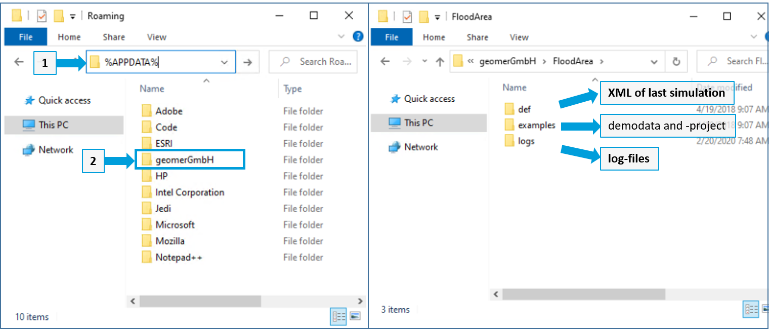
Please send us the FloodAerea.log and the fng.xml, you find this file in the temp or the output folder.
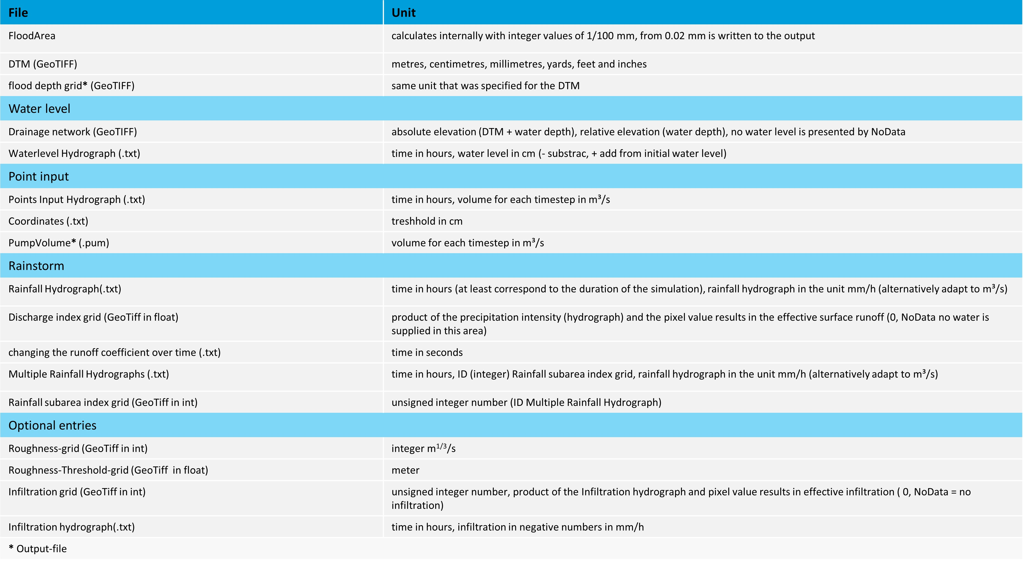
Overview of Files and Units
The following table shows an overview of all files and units used in FloodArea.
FAQ
The following describes and answers the most common problems and questions that reach our support:
The simulation aborts. What happened?
Go to the folder with the temporary data. Often the folder is identical to the output folder. Open the file: floodarea.log. Here you will find the reason for the abort.
Grid missmatch error : Dimension of parameters grid does not match with dimensions DTM
Raster extent and resolution of all input rasters must be identical to the digital terrain model (DEM/DTM). Deviations often occur during raster processing in ArcGIS. Always make sure to set the raster extent of the DTM in the environment settings. When converting from a feature class to a raster, you should also specify the DTM as a snap raster to ensure the raster cells align.
No projection information available or unsupported projection for file %f.
See the logfile for details. The coordinate reference system and/or projection system of at least one input raster does not match the digital terrain model. All rasters must have the same coordinate reference and projection system (same EPSG code). Additionally, the coordinate reference system used must be metric; so no degrees, decimal degrees, or map projections in feet or yards.
Grid value of raster is below the allowed minimum of %.2f. / Grid value raster is above the allowed maximum of %.2f.
The raster contains invalid values. For example, roughness rasters may only have values from 0 to 1,000, or runoff coefficient rasters may only have positive values.
Error during memory allocation. The available memory is insufficient.
Your calculation area might be too large or the resolution too fine. You can divide it or reduce the resolution using the ArcGIS Resample function.
UseVariableRoughness and UseInterpolatedRoughness are mutual exclusive.
Please correct the values in the AdditionalOptions section. Either the variable roughness function or interpolated roughness can be specified and used simultaneously.
StartTime must be at least 0.
Please correct the value in the TimeSetup section. The start time field is empty and must be filled with at least a 0.
Simulation duration must be at least 1 second.
Please correct the value in the TimeSetup section. The simulation time has an invalid input. The simulation must be at least 1 second. Note: the specification is in seconds.
Couldn’t read backup file.
The backup file could not be read or found. Reasons for this could be that the backup save interval is too long and another backup was still being written. Or the backup file was copied to another folder and cannot be found by FloodArea. Note: Do not move the backup folder. It’s also possible that the backup file is corrupted. In this case, delete the file and simulate from the beginning.
There is a geomer watermark in the result rasters.
This happens when an incorrect or invalid license file was specified. FloodArea doesn’t abort in this case but switches to demo mode. You can verify this in the floodarea.log.
Literature
Assmann, A., Krischke, M., Höppner, E. (2009): Risk maps of torrential rainstorms. In: Samuels, P., Huntington, S., Allsop, W., Harrop, J. (Hrsg.) (2009) Flood Risk Management: Research and Practice 48. ISBN 978-0-415-48507-4.
Holzhauer, V., Müller, M., Assmann, A. (2009): RISK-EOS flood risk analysis service for Europe. In: Samuels, P., Huntington, S., Allsop, W., Harrop, J. (Hrsg.) (2009) Flood Risk Management: Research and Practice: 46. ISBN 978-0-415-48507-4.
Assmann, A. (2008) Einsatzgebiete und Erstellung von Starkregen-Gefahrenkarten. In: Strobl, J., Blaschke, T. & Griesebner, G. (Hrsg.) (2008) Angewandte Geoinformatik 2007, Beiträge zum 20. AGIT-Symposium Salzburg: 750-755. ISBN 978-3-87907-464-8.
Assmann, A. (2007) Starkregen-Gefahrenkarten und Schutzkonzepte. In: Verband Region Rhein-Neckar (Hrsg.) 5. Hochwasserschutzforum Rhein-Neckar, Heft 4.
Assmann, A. & Herrmann, S. (2007) Geoinformationstechnologien als Instrument in Beteiligungsprozessen - Anforderungen und Möglichkeiten. In: Kuratorium für Technik und Bauwesen in der Landwirtschaft e.V. (Hrsg.) Geoinformationstechnologien zur Umsetzung der Wasserrahmenrichtlinie. KTBL-Heft 62: 16-30. ISBN 978-3-939371-36-6.
Assmann, A. Schroeder, M. & Hristov, M. (2007) High Performance Computing für die Rasterbasierte Modellierung. In: Strobl, J., Blaschke, T. & Griesebner, G. (Hrsg.) (2007) Angewandte Geoinformatik 2007, Beiträge zum 19. AGIT-Symposium Salzburg: 19-24. ISBN 978-3-87907-451-8.
Assmann, A., Grafe, M., Runge, I. & Thäger, F. (2006): Einflüsse des Berechnungsverfahrens und der Qualität der Grundlagendaten auf die Ermittlung überschwemmungsgefährdeter Gebiete. In: Hydrologie und Wasserbewirtschaftung 50, H. 1: 19-24. ISSN 1439-1783.
Assmann, A. (2005): Simulation von Überflutungsflächen und Deichbrüchen auf der Grundlage von Rasterdaten. In: Wittmann, J. und Xuan Thinh, N. (Hrsg.) (2005) - Simulation in den Umwelt- und Geowissenschaften, S. 109-116.
Assmann, A. & Jäger, S. (2003): GIS-Einsatz im Hochwassermanagement. In: Strobl, J., Blaschke, T. & Griesebner, G. (Hrsg.) (2003) - Angewandte Geographische Informationsverarbeitung XV, Beiträge zum AGIT-Symposium Salzburg 2003, S. 7-14.
Assmann, A. (2003): GIS Einsatz bei der Planung dezentraler Hochwasserschutzmaßnahmen. - arcaktuell 1/2003: 28-29.
Assmann, A. & E. Ruiz Rodriguez (2002): Modellierung im GIS - Erfahrungen beim Einsatz eines Rasterbasierten Modells für Überschwemmungssimulationen. - GeoBIT 7/2002: 14-16.
Disse, M, Kamrath, P., Wilhelmi, J. und Köngeter, J. (2003): Simulation des Hochwasserwellenablaufes und der Ausbreitung von Überflutungsflächen unter Berücksichtigung von Deichbrüchen. - Wasserwirtschaft 5/2003: 24-29
Disse, M. & Assmann, A. (2003): Bestimmung der Überflutungsflächen infolge von Deichbrüchen mit GIS-basierten Werkzeugen. - Hydrologie und Wasserbewirtschaftung 47, H.6: 228-233.
Disse, M., Grätz D. & M. Hammer (2002):Auswirkungen von Deichbrüchen auf den Wellenablauf und die betroffenen Überflutungsflächen am Beispiel des Niederrheins. - 3. Forum Katastrophenvorsorge.
Disse, M., Hammer, M. & J. Wilhelmi (2003): Quantifizierung der Hochwassergefährdung für die Rheinanlieger unter Berücksichtigung von Deichversagen. - 4. Forum Katastrophenvorsorge.
Disse, M., Hammer,M., Merz, B., Thieken, A. & G. Blöschl: Vorsorgender Hochwasserschutz im Rheingebiet - welchen Beitrag leistet das DFNK? - Ergebnisse aus dem Deutschen Forschungsnetz Naturkatastrophen.
Jäger, S. (2002): Ein neuer Rheinatlas - Hydrodynamische Modellierung für eine bessere Hochwasservorsorge. - arcaktuell 2/2002: 38-39.
Gemmer, M. (2003): GIS/RS-Based Flood Risk Mapping for the Eastern Honghu Flood Diversion Area. - Journal of Lake Sciences 15: 166-172.
Gemmer, M. (2003): Transferability of European Flood Impact Estimation Techniques to the Yangtze River Catchment and Possible Adaptations. - Journal of Lake Sciences 15: 173-183.
Ruiz Rodriguez, E., Zeisler, P. & A. Assmann (2003): GIS-Einsatz zur Gefahrenabwehr im Hochwasserfall. - Hochwasserschutz und Katastrophenmanagement 4/03: 28-30.